FORCLIME
Forests and Climate Change ProgrammeTechnical Cooperation (TC Module)
![]()
Select your language


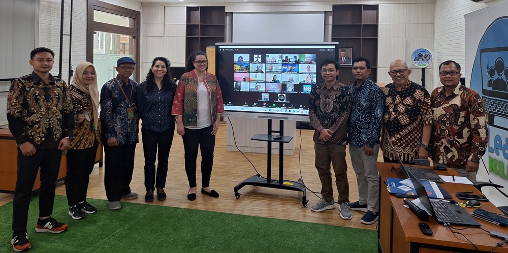
The Environment and Forestry Human Resources Training Center (EF HR Training Center) at the Ministry of Environment and Forestry (MoEF) held a workshop that aimed to evaluate the development of Massive Open Online Courses (MOOC). This workshop was held both offline and online from 19 – 22 March 2024 at the office of the Environment and Forestry Education and Training Center in the city of Bogor and also involved a visit to the office of the Bogor Environment and Forestry Training Center (BPLHK) in Rumpin, West Java. The activity was opened and closed by the Head of the EF HR Training Center, Dr. Kusdamayanti, M.Sc., and was attended by lecturers and managers from the EF Education and Training Center, the BPLHK, the eLearning team, representatives from the Directorate of Social Forestry and Environmental Partnerships (PSKL), representatives from the Ministry of Environment and Forestry's Personnel Bureau and representatives from the Regional Community Forestry Training Center (RECOFTC), an international non-profit organization that focuses on the development of community forestry capacity within the Asia-Pacific region. This workshop was a follow-up to the MOOC development kick-off, which was held in January 2024.
The workshop aimed to assess the readiness of the EF HR Training Center to initiate and develop a MOOC programme. In this regard, the activities that were organized were varied in nature and encompassed literary studies, observations and semi-structured interviews with relevant stakeholders, particularly those under the administration of the EF HR Education and Training Center.
These activities resulted in a report that addressed several areas, specifically: (a) An overview of current conditions at the EF HR Training Center regarding eLearning development, (b) Gap analysis regarding MOOC development at the LHK HR Training Center (including technological aspects, human resource capacity and teaching/training materials), and (c) Recommendations for MOOC development at the EF HR Training Center.
“As Head of the EF HR Training Center, I would like to express my thanks to various parties, including GIZ, which has offered its continuing support for the development of distance learning through eLearning. I would also like to thank the RECOFTC, which has been supporting Gender Mainstreaming training activities through MOOC; the Directorate General of PSKL, which has been collaborating in order to develop companion training in social forestry; and the Planning Bureau and Personnel Bureau," announced Dr. Kusdamayanti during her closing speech.
For more information, please contact:
Danan P. Hadi, Adviser for Remote Sensing/GIS and eLearning
Naufal Abdillah, Junior Adviser for Human Capacity Development
Edy Marbyanto, Strategic Area Manager for Human Capacity Development
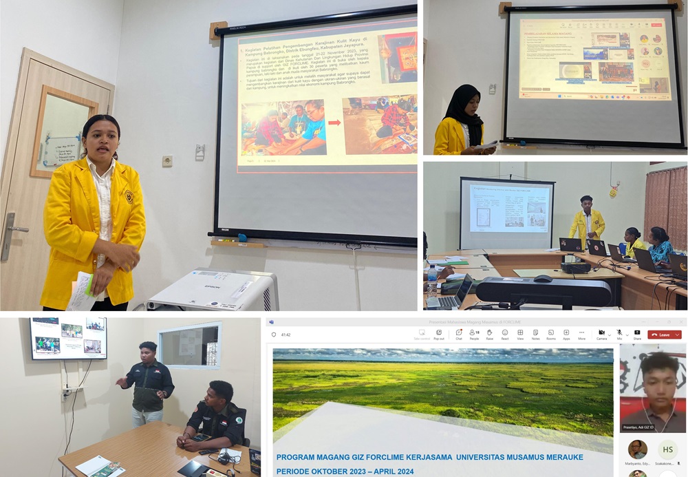
Since 2019, FORCLIME has organized an internship programme for students from universities in Tanah Papua. During 2023, FORCLIME continued with its internship programme, which this year was organized for seven students drawn from four universities across Papua, specifically Papua University, Cenderawasih University, Ottow Geissler University Papua and Musamus University. Prior to their deployment in the field in order to participate directly in the implementation of FORCLIME activities, intern students attended an introductory workshop, which aimed to increase their overall knowledge and skills, particularly in relation to FORCLIME activities. The internship programme was implemented for a period of six months between 3 October 2023 and 4 April 2024.
Prior to the end of the programme, the interns made a presentation of what they had learned during their internships. This session also aimed to evaluate FORCLIME in terms of its organization of the internship programme. This presentation was divided into four sessions that were held from 22 – 28 March 2024 in line with the following schedules and presenters:
1. Hana Soakakone and Pradista Dwi Saputri from the Faculty of Mathematics and Natural Sciences, Cenderawasih University (22 March 2024).
2. John B. Hassor and Br. Yosina Demetouw from the Forestry Study Program, Faculty of Agriculture, Forestry and Marine Sciences, Ottow Geissler University, Papua (25 March 2024).
3. Adi Prasetyo from Musamus University (25 March 2024).
4. Papua Pastimair Deijka Peday and Rizal from the Faculty of Forestry, University of Papua (28 March 2024).
“Through the internship programme, students not only received the opportunity to study in college but also to complete internships. So that they could get to know the working environment better, while the universities also had the opportunity to learn about FORCLIME and its various projects. This means that the universities receive inputs and thus get to improve their programmes in line with developments that relate to forestry and environmental issues, as implemented by FORCLIME," explained Deputy Dean 3 of Papua University, Dr. Petrus A. Dimara.
Lecturers from each university expressed their appreciation for FORCLIME‘s internship programme. From the presentation given, these lecturers determined that the participating interns had been given the opportunity to put the knowledge that they had learned on campus into practice.
“We would like to thank GIZ for the collaboration with Cenderawasih University, which was originally initiated back in 2019. During this time we have witnessed our students completing their tasks with skill and becoming increasingly confident. Another important message to convey is that FORCLIME internship alumni quickly manage to secure jobs after graduation," explained Dr. Noper Tulak, a lecturer from Cenderawasih University.
The attending lecturers also expressed their hope that the internship programme would continue due to its enormous benefits. Moreover, the lecturers also expressed the hope that the implementation of the internship programme would be brought into line with the university schedule so that it won‘t interfere with lectures.
For more information, please contact:
Anna Manyakori, Adviser for Sustainable Forest Management and Coordinator for Papua Province
Otniel Effruan, Junior Adviser for Rural Livelihood, Forest Management and Conservation Southwest Papua Barat
Edy Marbyanto, Strategic Area Manager for Human Capacity Development
Mohammad Sidiq, Strategic Area Manager for Sustainable Forest Management and Coordinator for Tanah Papua
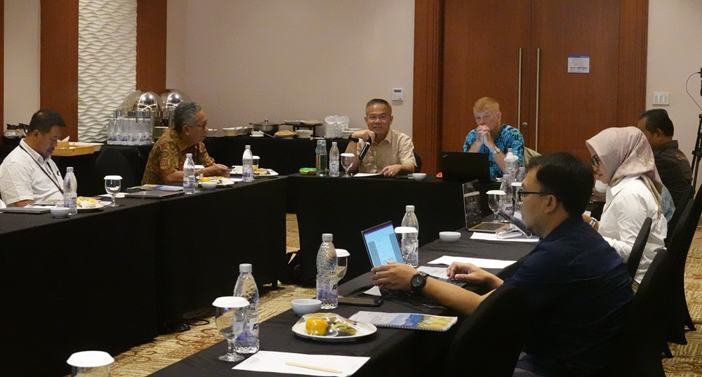
In order to report on the implementation of FORCLIME activities during 2023 and also to present FORCLIME's work plan for 2024, the Forestry Planning Bureau at the Ministry of Environment and Forestry (MoEF), as FORCLIME's Project Executing Agency (PEA), held a hybrid project technical committee (PTC) meeting on 21 February 2024. The meeting was opened by the Head of the MoEF’s Planning Bureau, Dr. Apik Karyana, and was attended by PTC members and various parties who were representing Echelon II of the Ministry of Environment and Forestry. The meeting was also attended by working partners in FORCLIME working areas in Central Sulawesi Province (Lore Lindu National Park; the Forestry Service), in Papua Province (the Forestry and Environment Service; the Center for Conservation and Natural Resources [BBKSDA] in Papua), in Southwest Papua Province (the Environment, Forestry and Land Service; the Center for Conservation and Natural Resources [BBKSDA] in Southwest Papua).
Dr. Apik commenced his speech by reflecting on the long-established Indonesian-German cooperation. "We have both witnessed how the close cooperation between the two countries has produced significant results through the Social Forestry Development Program in Sanggau, West Kalimantan. This initiative has become a milestone in the history of the Social Forestry practices that we are continuing to develop today, a synergy of progress and sustainability which is our common heritage.”
During the meeting, working partners at the national and regional levels expressed their gratitude for FORCLIME's support, including the Head of the Human Resources Training Center for Environment and Forestry, Dr. Kusdamayanti. During her speech, Dr. Kusdamayanti explained that until 2023 the collaboration with GIZ had greatly helped the Training Center, particularly in relation to the development of eLearning involving hardware, software and brainware that was carried out through workshops, training sessions and activities in the field.
In terms of the work plan for 2024, which is FORCLIME 4.0’s final year, all of the relevant partners have expressed the hope that the remaining time until December 2024 will continue to be utilized in order to maximize support for partnering work programs at both the national and regional levels. In addition, the partners also hope that the follow-up program, namely FORCLIME Reloaded, will continue to support the strategic plan (Renstra) of the Ministry of Environment and Forestry, as well as related agencies across each of the various provinces in which FORCLIME works.
For more information, please contact:
Pipin Permadi, Senior Adviser for Strategic Planning and Liaison Officer
 |
Supported By: |
 |